Skip to content
Apuseni & Țara Moților Attractions

Apuseni & Țara Moților Attractions

Spectacular places 20 min – 1.5 h from camp

Camping Brăzești sits in the heart of the Apuseni Mountains, on the Arieș Valley (DN75) between Turda and Câmpeni, in Alba County, Transylvania. Our privileged position makes us the ideal base for exploring the Apuseni and wider Transylvania: within 13 to 55 kilometres you'll find some of Romania's most spectacular sights, from caves holding European records and travertine waterfalls to monument villages, Roman galleries, and places that exist nowhere else on earth.

84,000

Bats in a single cave

Huda lui Papară shelters the largest bat colony in Europe, inside one of Romania's longest caves. Just 15 km from the campsite.

3,800

Years of ice at Scărișoara

The Scărișoara glacier is 22.5 m thick with a volume of 75,000 m³, Romania's largest underground glacier and one of the biggest in Europe.

102 m

Height of the Hall of Wonders

The Hall of Wonders inside Huda lui Papară measures 56 × 92 m with a height of 102 m, Romania's largest underground chamber. A natural cathedral beneath the earth.

Top recommendation

Scărița-Belioara Trail
Top pickHiking · Mountain Circuit · Muntele Mare, Alba County
25 km

Poșaga de Sus · Muntele Mare

Scărița-Belioara Trail

25 km from campsite

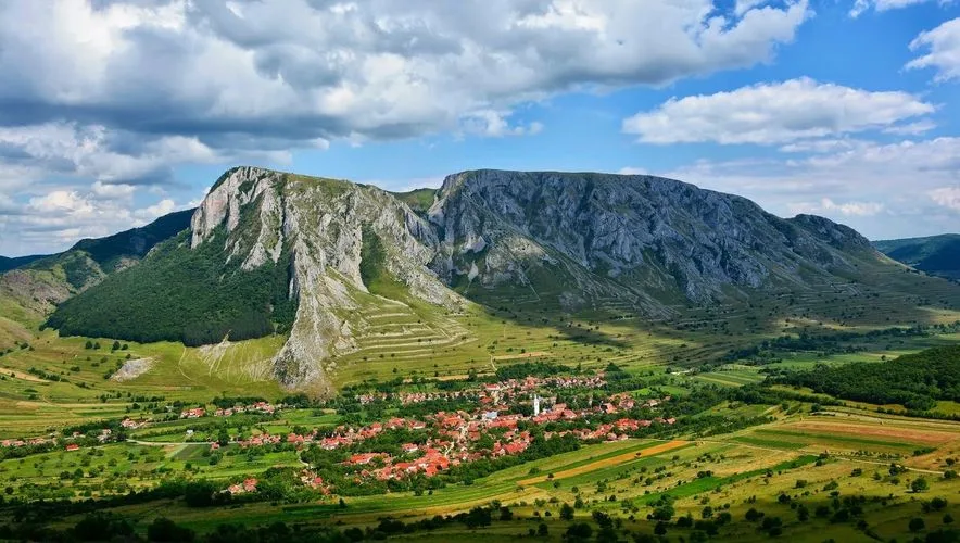
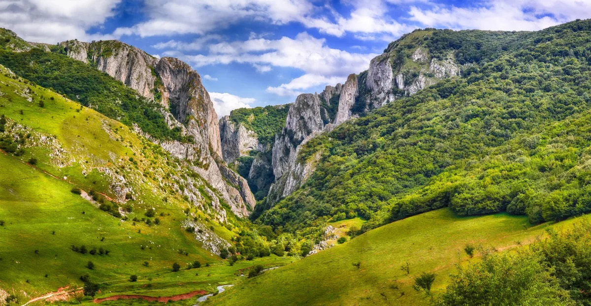
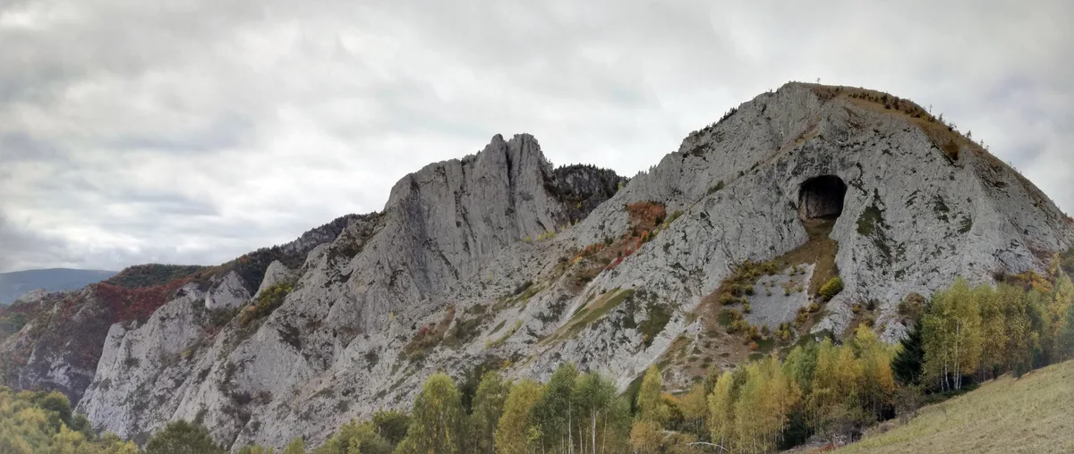
The Scărița-Belioara Geo-Botanical Reserve is widely regarded as the finest single-day hike in the Apuseni Mountains. Located in the Muntele Mare massif, Alba County, the reserve encompasses the Sesul Craiului limestone plateau, Scărița Peak at 1,382 m, and the dramatic headwalls of the Belioara Valley, 450 hectares hosting numerous rare plant species.

The circuit starts from Poșaga de Sus and climbs through dense forest, alternating between lush vegetation and exposed ridges. At 1,200 m you reach the La Răscruce saddle, then the trail ascends to a suspended plateau offering near 360-degree panoramas toward the Trascău Mountains, Muntele Mare summit (1,826 m) and Muntele Băișorii. The themed 'Colours of Nature' path with six information panels enriches the educational experience.

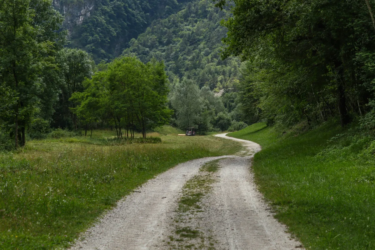
The full circuit takes 4–5 hours with approximately 790 m of elevation gain and an easy-to-moderate difficulty rating. In autumn, when forests blaze in red, orange and gold, Scărița-Belioara becomes one of the most photographed places in Romania. The access road is well-surfaced and suitable for all vehicles.

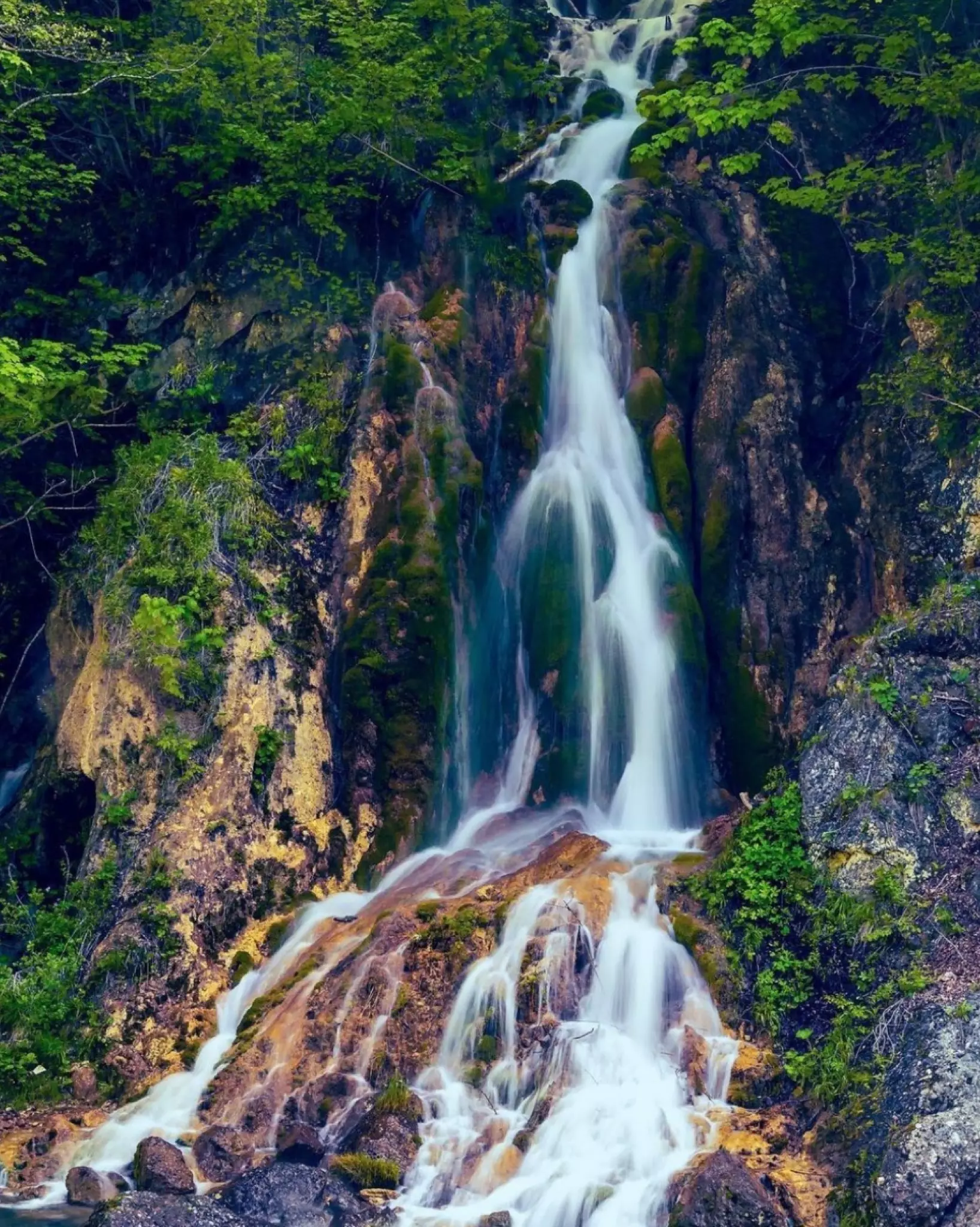
Camp tip: Set off early from Brăzești and combine Scărița-Belioara with a stop at Șipote Waterfall on the way back, just 13 km from camp. A perfect Apuseni day.

4–5 hours8–12 km circuitEasy-to-moderate difficultyParking at trailheadStart: Poșaga de SusOpen year-round

All attractions

Huda lui Papară Cave
Cave · National Record
15 km
Largest bat colony in Europe

Sălciua · Trascău Mountains

Huda lui Papară Cave

Huda lui Papară holds every superlative in the Trascău Mountains: Romania's longest, deepest and most challenging cave, home to the largest underground chamber in the country (Hall of Wonders, 56×92 m, 102 m high), the longest underground watercourse and the country's largest underground waterfall. It shelters approximately 84,000 bats, Europe's largest colony. Its formation began around 2 million years ago through continuous erosion of limestone rock.

The cave entrance is a monumental stone portal over 40 m high, impressive even before you step inside. A turbulent underground river flows through, forming lakes and cascades. Access is permitted only with an authorised guide, wetsuit and specific equipment. Reached from Sălciua de Jos along the communal road toward Sub Piatra hamlet, about 6 km from the DN75 road.

Authorised guide requiredBat season: Apr–OctParking: Sub Piatra5,200 m of galleries in total
Șipote Waterfall
Travertine Waterfall
13 km
Constant flow year-round

Sălciua de Jos · Arieș Valley

Șipote Waterfall

Șipote Waterfall (also called Travertine Waterfall Șipote) is a natural gem 2 km from Sălciua village. It is a complex karst phenomenon: water collects on the Bedeleului Plateau (1,100–1,200 m), travels through limestone via underground channels, and resurfaces through three springs at the base of a 100 m rock face. The Șipot stream then descends roughly 800 m along a steep channel, from 700 m down to 430 m, creating the lower fall (visible directly from DN75) and the upper fall.

The travertine bed over which the water flows produces fairy-tale imagery: falls up to 15 m high, natural limestone dams and pools. The flow is remarkably consistent regardless of season, making it a worthwhile visit at any time of year. A rustic car park sits near the junction with the Arieș; a marked trail (red cross) climbs to Poiana La Șipote in roughly one hour.

1 h walk from SălciuaOpen year-roundVisible from DN75Falls up to 15 m high
Sălciua Panorama Point
Viewpoint
15 km

Sălciua · Arieș Depression

Sălciua Panorama Point

Sălciua occupies a unique place in Apuseni geography: set in the middle Arieș basin between the Trascău Mountains and Muntele Mare, at altitudes ranging from 700 to 1,400 m, the village is surrounded by exceptional karst scenery. The rolling terrain framing the broad Arieș floodplain provides natural vantage points with sweeping views over the valley and the slopes rising toward the Bedeleului Plateau.

The spot is ideal for photographers at sunrise and sunset, when warm light colours the valleys and cliffs. Trails depart from here toward the Vânătările Ponorului Reserve, Dâlbina Waterfall, Huda lui Papară and Șipote Waterfall, making Sălciua a perfect hub for ticking off multiple attractions in one day.

Best at sunrise and sunsetLandscape photographyFree accessHub for 4 nearby attractions
Dâlbina Waterfall
Waterfall and Nature Reserve
17 km

Sălciua · Vânătările Ponorului

Dâlbina Waterfall

Dâlbina Waterfall lies within the Vânătările Ponorului Nature Reserve, a complex and spectacular karst system where three streams (Valea Seacă, Valea Ponorului and Valea Poienii) converge in a huge doline, disappear underground and re-emerge in Huda lui Papară cave. In rainy seasons a temporary lake forms on the doline floor, a rare karst phenomenon. The waterfall stands 18 m high with a 25 m-wide split across the rock face; travertine formations deposited over centuries make it even more dramatic.

The trail starts in Sălciua de Jos toward the Dumești hamlet (paved road all the way up). Dumești itself is worth a stop: from the elevated plateau you enjoy a superb view over the entire Sălciua depression. From the car park, the waterfall is roughly 40 minutes on foot along a clearly signed trail.

40 min walk from car park18 m highParking in DumeștiNature reserve
Rimetea
Monument Village
45 km
European Rural Restoration Programme 1999

Trascău Mountains · Alba County

Rimetea

Rimetea is one of Romania's most beautiful villages, a monument village designated by the European Rural Restoration Programme in 1999, with white houses and green shutters in neoclassical style, some dating to 1668. Nestled at the foot of Piatra Secuiului massif (1,711 m), the village hides an optical phenomenon unique in Romania: a limestone gorge causes the sun to appear to rise twice each summer morning for residents in the northern part of the village.

Hikes up Piatra Secuiului and to the ruins of Trascău Fortress (Colțești) attract nature lovers and history enthusiasts alike. The slopes are popular with paragliding pilots, while rafting is available on the Arieș river a few kilometres away. The neat white streets make Rimetea one of the most photographed settlements in the Apuseni.

Monument villagePiatra Secuiului hikeParaglidingRafting on the Arieș
Transapuseana Road and Râmeț Gorge
Scenic Road and Gorge
approx. 30 km
Romania's 2nd longest mountain road

Alba County · Aiud–Abrud

Transapuseana Road and Râmeț Gorge

Transapuseana (DJ 107I) is Romania's second longest mountain road after the Transfăgărășan: 78 km from Aiud to Abrud, through isolated picturesque villages with wooden houses and thatched roofs, climbing to over 1,100 m. Part of the route follows a Roman road built 2,000 years ago. Along the way you pass through Râmet, Ponor, Mogoș and Bucium, deep valleys and dense forests, an authentic Romania barely touched by mass tourism.

The route includes Râmeț Gorge (spectacular karst formations ideal for short hikes) and Râmeț Monastery, founded in the early 13th century, one of Transylvania's oldest monastic establishments. Near Bucium: Detunata Flocoasă and Detunata Goală reserves; the narcissus meadow (Poiana cu narcise) is at Negrileasa, not Neagra.

Self-drive tour78 km totalRâmeț Monastery, 13th centuryAuthentic alpine scenery
Turda Salt Mine
Salt Mine and Underground Attraction
55 km
In the world's top underground destinations

Turda · Cluj County

Turda Salt Mine

Turda Salt Mine is one of Romania's, and the world's, most spectacular tourist destinations: a working medieval salt mine transformed into an underground amusement park, 112 m below ground level. The enormous galleries carved into rock salt house a carousel, a panoramic Ferris wheel (operating underground), a mini-golf course, a rowing lake and spectator stands. A constant temperature of 12°C and air rich in salt aerosols create a therapeutic environment especially beneficial for respiratory conditions.

Turda Salt Mine has featured in international publications and in rankings of the world's most spectacular underground places. It is an ideal destination on rainy days or for family visits with children of any age.

12°C constant temperatureUnderground activitiesTicket requiredIdeal for families
Turda Gorge
Hiking and Rock Climbing
50 km
Over 70,000 visitors per year

Turda · Nature Reserve

Turda Gorge

Turda Gorge is one of the most majestic geological formations in the Apuseni Mountains: limestone walls over 300 m high stretching for roughly 3 km, sculpted by the Hășdate River over geological eras. The nature reserve offers a network of trails for all difficulty levels, easy walks suitable for families with young children up to technical routes for experienced climbers scaling the walls.

The calcicole flora of Turda Gorge is exceptionally diverse, making it a destination for botanists and naturalists too. Rimetea lies 30 km away, so both attractions can easily be combined in a single day.

3 km gorgeSport climbingSeasonal entrance feeSuitable for all ages
Scărișoara Ice Cave
Underground Glacier
approx. 35 km
Romania's largest underground glacier

Gârda de Sus · Apuseni National Park

Scărișoara Ice Cave

Scărișoara Cave shelters Romania's largest underground glacier and one of the biggest in Europe: over 75,000 m³ of fossil ice, 22.5 m thick, with an incredible age of over 3,800 years. The cave is 700 m long and 105 m deep; a constant interior temperature of around 4°C keeps the ice perfect even in the height of summer. Access involves descending through a 48 m shaft, an experience in itself.

The road to the cave passes through Ordâncușa Gorge (4 km long, among the narrowest in the country with widths of just 4–6 m in places), which is a geological spectacle in its own right. Nearby are the Tauz and Cotețul Dobreștilor springs for fans of karst phenomena.

4°C constant temperatureOpen year-roundOrdâncușa Gorge en routeTicket required
Roman Galleries and Mining Museum
UNESCO World Heritage
40 km
UNESCO World Heritage Site

Roșia Montană · Alburnus Maior

Roman Galleries and Mining Museum

Roșia Montană, known in antiquity as Alburnus Maior, is Europe's oldest continuously inhabited settlement with a tradition of precious metal mining. The site preserves over 7 km of Roman galleries chiselled by hand 2,000 years ago, plus 80 km of medieval tunnels. Golden threads are still visible in the gallery walls today.

The museum complex comprises three sections: Alburnus Maior Mine (descend 157 steps into the Roman underground labyrinth), Mina Courtyard with mining equipment and archaeological finds displayed in the open air, and the Mining Museum with geological maps, tools, historical photographs and Roman artefacts. UNESCO World Heritage inscription confirms the site's outstanding universal value.

UNESCO World HeritageTicket, 10 RON/personMon–Fri, 8am–2pm7 km of Roman galleries
The Sunken Church of Geamăna
Unique in the World
20 km
One of the most photographed places in Romania

Geamăna · Alba County

The Sunken Church of Geamăna

A place you won't find anywhere else: an entire village gradually swallowed by the tailings pond of the Roșia Poieni copper mine. Since 1986, when discharge of chemical-laden mining waste began, over 1,000 residents were relocated and their homes, yards and village cemetery now lie buried under tens of metres of toxic sludge.

The settling pond covers roughly 13 hectares and on sunny days turns spectacular shades of red, green and vivid yellow, acid, surreal colours produced by chemical reactions. From this coloured water rises the steeple of the submerged church, the tallest structure of the former village and the only visible witness to a vanished community. A place that evokes equal parts melancholy and wonder, visited each year by thousands of photographers and travellers. Warning: do not approach the lake shore.

Unique photographyBest light: early morningKeep away from the lake shoreAccessible by car

Find us in the heart of the Apuseni

Camping Brăzești — 4 Main Street, 515301 Brăzești, Alba County, on DN75 (Turda–Câmpeni), 6 km from Baia de Arieș (shops, groceries). Catering to order from camp. Attractions above are 13–55 km away, perfect for day trips.

GPS: 46.3971 N, 23.3160 E · 4 Main Street, 515301 Brăzești, Alba County